
Marco Island News Naples News Collier County News Florida News


MINN

MINN

MINN
MINN

MINN
MINN
MINN
MINN


Marco Island & Naples News.
Sometimes Funny, Sometimes Serious, Always Honest.
Facebook
Twitter
LinkedIn
Pages
- Florida Solves HIV by Pretending It’s 1993 Again
- Small Plane Makes Emergency Landing at Naples Airport, No Injuries Reported
- Naples High School Student Arrested After Deputies Find Drugs and Razors
- SOUTH FLORIDA BRACES FOR “ARCTIC BLAST,” PANIC ENSUES OVER 40-DEGREE TEMPERATURES
- Semi-Truck Rollover Blocks Lanes on I-75 in Bonita Springs
- Tiny but Mighty Pineapple Upside-Down Cake
- Florida vs. The Signatures: A Prestigious Ballet of Bureaucracy and Bud
- Florida Gas Prices Drop 17 Cents in Just 10 Days
- Health Inspection Report: Perfect Scores And Problem Kitchens
- A Trio of Cold Fronts Marches In, Demanding Attention and a Light Jacket
- Cold Front
- ‘Livid and Shocked!’ — When Southwest Florida’s Weather Forecast Turned Petty
- HOA Achieves Historic Legal Defeat, Bills Everyone Anyway
- About Time: Florida Moves to End Capture of Endangered Marine Wildlife for Aquariums
- ONE PERSON SERIOUSLY INJURED AFTER CRASH INVOLVING DUMP TRUCK
- Florida Proudly Leads the Nation… in Not Getting the Flu Shot
- Naples Teen Arrested After Allegedly Calling for Violence Against ICE Agents Online
- Florida Says It Found Toxins in Infant Formula, but Provides No Supporting Data
- When “Proof of Funds” Turns Into Proof You’ve Seen Too Much
- Florida Home Prices Begin to Fall, Raising Fears of a Looming Housing Crash
- Florida Lawmakers Push Tougher Rules to Keep Drivers Off Their Phones
- Federal Judge Rules Florida Violated Medicaid Recipients Rights With Confusing Termination Notices
- NAPLES, FL: WHEN YOUR POOL BOY HAS TEETH AND ZERO REGARD FOR HOA RULES
- PERSON STABBED DURING DOMESTIC DISTURBANCE
- Health Inspection Report: 15 Restaurants Earn Perfect Scores, Dozens Face Follow-Ups in Collier County
- Fire Damages Vehicles at Naples Car Lot, No Injuries Reported
- One Dead After SUV Crashes Into Lake in Heritage Bay
- Around 40 Killed, More Than 100 Injured in New Year’s Eve Fire at Swiss Ski Resort Bar
- COLLIER COUNTY, Fla. — Four people were killed and three others seriously injured
- Multi-Vehicle Crash Shuts Down I-75 at Immokalee Road in North Naples
- THE NEW RULES
- New College of Florida
- Port Marco Complex: Do We Really Need a Mini-Miami on Bald Eagle Drive?
- School Pickup Turns Into Python Sighting on Marco Island
- South Florida Businesses Hope Canadians Return as Winter Season Begins
- Florida Bear Hunt Hits Midpoint, State Says “Trust Us, It’s Fine”
- Collier County Restaurant Inspections: Dozens Earn Perfect Scores, While Others Face Warnings and Follow-Ups
- Hit-and-Run Near Lely High School Leaves Girl Injured, Sparks Safety Concerns
- NAPLES TO ADD 54 MORE LICENSE-PLATE READER CAMERAS, BECAUSE ONE CAN NEVER BE TOO AWARE (OR OBSERVED)
- Marco Island Politely Declines to Build Tiny Fancy Islands in Its Canals
- FLORIDA TAKES ANOTHER LONG, DEEP LOOK AT LEGAL WEED
- Marco Island Christmas House Decorating Contest Announces 2025 Finalists
- Federal Judge Denies Request to Shut Down Florida’s ‘Alligator Alcatraz’ Detention Facility
- Splash Into the Holidays at Sun-N-Fun Lagoon!
- Man Accused of Brake-Check Crash, Dragging Victim Behind Golf Cart on Marco Island
- LICENSE PLATE CONFUSION GRIPS THE SUNSHINE STATE
- Collier County ‘Cat Burglar’ Turns Out to Be, Shockingly, a Cat
- NAPLES RINGS IN THE NEW YEAR… EVENTUALLY
- FLORIDA MAN STRIKES (A CONSTITUTIONAL NERVE) AGAIN
- Collier County Restaurant Inspections: Dozens Ace the Test, While Others Get a Second Look
- FLORIDA MAN STRIKES AGAIN: Lawmakers Propose Bill to Finally Let You Break Up With Your HOA
- License Plate Readers Promise Safety, Deliver a Side of Surveillance
- Trump Expected to Order Marijuana Reclassification; What It Could Mean for Florida
- Collier County Clerk’s Marco Island Satellite Office is Now Approved to Receive Passports
- Residents in Florida Can Anticipate New Laws Coming Into Effect Next Year
- Florida Homeowners Could See Insurance Rate Cuts After Years of Increases
- 1 Injured, 1 in Custody Following Shooting at Paradise Sports Complex in Collier County
- Collier County Gives Green Light to New Rural Village, Paving the Way for 3,205 Homes in East Collier
- 7-Vehicle Crash Leaves One Dead, Shuts Down I-75 in Collier County for Hours
- Collier County Greenlights 1,299-Home Development With Affordable Housing Component
- 6-Year-Old Girl Dies After Go-Kart Accident at Port St. Lucie Adventure Park
- Governor’s Budget Proposal: Now Featuring 0% Effort and 100% Pretentious Neglect
- Man Arrested for Aggravated Assault in Golden Gate Estates After Gas Station Incident
- NEW CASE OF FLESH-EATING BACTERIA REPORTED IN LEE COUNTY
- Trump Finally Unites America… By Renaming Soccer?
- Collier County Restaurant Inspections: 30 Perfect Scores — and 45 That Didn’t Make the Cut on the First Try
- Florida to Trump: “Please Stop Trying to Turn Our Beaches Into Oil-Flavored Soup”
- Marco Island’s Latest Development Drama: Burgers by the Cemetery or a Mega-Hotel by Winn-Dixie?
- Naples HDR
- Deputies Heroically Save USPS From 50 Xanax Pills, Briefly Shutting Down Civilization Near RSW
- Florida Wildlife Officials Announce Bold New Strategy: Science-Free Conservation!
- Lack of Rain Deepens Drought, Heightens Wildfire Concerns Across Southwest Florida in 2026
- Naples Pier: A Masterclass in Perpetual Motion (and Bureaucracy)
- South Florida’s Commuters Could Soon Take Flight: Inside Archer Aviation’s Air-Taxi Network
- Florida Politicians Suddenly Agree on Something—Alert the Media
- Low-Cost Pet Vaccine Clinic
- Get Ready, America: China’s Food and Drink Chains Are Moving In
- A fast-moving early-morning house fire on Estey Avenue
- Collier County Restaurant Inspections: 33 Perfect Scores — and 33 That Didn’t Make the Cut
- Florida Power & Light: Enlightening Us With Ghosts, Denials & Billion-Dollar Oopsies
- MARCO ISLAND’S HIDDEN HISTORY: 30 LITTLE-KNOWN FACTS ABOUT A TROPICAL PARADISE
- 50 Absurd Facts About Florida You Never Knew
- Historians Say America’s First Thanksgiving Happened in Florida — Not Plymouth
- The Great Ponzi Swindle: Miami’s Finest Financial Farce
- Motorcyclist Declared Trauma Alert After Collision Under I-75 Bridge on Immokalee Road
- Juvenile Beaten, Robbed in Marco Island; Three Suspects on the Run
- Turkey Tourism Takes Flight in Florida: Wild Birds Now More Booked Than Beach Resorts
- One Dead, Another Seriously Injured Following Rollover Crash on Vanderbilt Beach Road
- Florida says: “No TikTok till you hit puberty” — but wait
- Celebrate the Season with Parks & Recreation
- Car Plunges Into Canal Near San Marco Bridge
- South Florida Lawmaker Proposes Sweeping Property Tax Break for Seniors
- Naples Drug Bust: The “Luxury Sampler Pack” Nobody Ordered
- Judge Says Florida’s Bear Hunt Can Go On — Because What Could Possibly Go Wrong?
- Naples Housing Market Cools as Prices Slide Nearly 7%
- Whatever You Do, Don’t Toss Those Old Comics: Attic Find Shatters World Record With $9.12 Million Superman Sale
- DAS Hosts Kitten College Educational Event
- Severe Weather Threatens to Disrupt Peak Thanksgiving Travel Across the U.S.
- Florida’s Magical Vanishing Property Tax Trick
- SHOP
- Collier County Restaurant Inspections: 41 Restaurants Earn Perfect Scores, 35 Fall Short on First Check
- Naples, But Make It Explosive:
- Judge Backs DeSantis, Marijuana Legalization Effort Takes a Big Ol’ Hit
- One Seriously Injured After Battery Outside Naples DMV; CCSO Investigating
- Florida’s Coastline: Now Serving Freshly Drilled Democracy!
- Florida Power & Light Turns Up the Heat… on Your Wallet!
- Naples’ Lavish Lifestyle Enthusiast Accidentally Invents the World’s Most Predictable Ponzi Scheme
- Naples, Florida — A Winter Wonderland on the Gulf Coast
- Naples Man Arrested on DUI Manslaughter Charge After Fatal Motorcycle Crash
- Operation “Home for the Holidays” Recovers 122 Missing Children Across Florida in Massive Multi-Agency Sweep
- Naples Man Shocked to Learn IRS Frowns Upon Cash Mountains, Creative Accounting
- Motorcyclist Killed in Collision With Pickup Truck in Naples; Southbound Lanes Shut Down
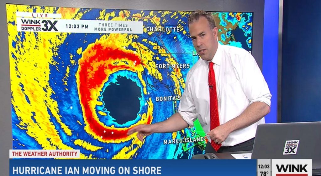
- Collier County Advances Rebuild of Marco Island CCSO Substation After Hurricane Ian Destruction
- Three Seriously Injured in Head-On Crash on Everglades Blvd in Golden Gate Estates
- Marco Island This Week: Nov 17–24, 2025 — Sunshine, Holiday Cheer, and Local Happenings
- Vehicle Fire in North Naples Leaves One Dead
- 40 Restaurants Achieve Perfect Scores and 40 establishments received warnings
- Light Up Southwest Florida: Get Your Holiday Display on the Map!
- Tampa’s Chicken Yoga: Because Your Downward Dog Wasn’t Humiliating Enough
- How to silence robocalls on iPhone and Android
- Naples Man Arrested After Street Racing at 150 MPH on I‑75 in Collier County
- Tragic Head-On Collision on Immokalee Road Claims Two Young Lives
- BREAKING NEWS FROM THE LAND OF Tumbleweeds & Tragic Iconography: Buddy Holly’s Crosswalk to Become History
- Florida’s Big Brain Move
- Caxambas Park to Resume Fuel Services Saturday, November 15
- Road Rage Royale on the SS Jolley Bridge
- Collier County Democratic Party to Hold “Stand Up For Immigrants” Rally on Saturday
- Florida Hit With 191 Million Spam Calls a Month — But Honestly, We’re Flattered
- Briggs Boardwalk: A Peaceful Slice of Wild Florida
- Marked Safe from the Great Marco Island Winter of 2025
- Foodie Guide Review: Slice Shop — New York-Style Pizza by the Slice Arrives in Downtown Naples!
- FOODIE REVIEW: Taco Bell’s Two-Story Fiesta on the Strip
- Florida Cold Snap Chaos: Locals Freeze While Snowbirds Frolic
- Florida Declares War on Puffing — Except for the Fancy Stuff
- Naples’ Gone Wild: Ex-Property Manager Turned Alleged Million-Dollar Con Artist Found Living His Best (Prison) Life in Colombia
- Police Investigating Possible Explosive Device Found on Marco Island
- Marco Island Executive Airport Opens New $3.5 Million Bulk Aircraft Storage Hangar
- Oakes Farms Files Lawsuit Against Former Executive, Alleging Multi-Million-Dollar Theft
- Collier County Restaurant Inspections: 43 Restaurants Didn’t Pass the First Inspection — 39 Earned a Perfect Score
- Marco Island This Week: Music, Merriment, and a Dash of Holiday Spirit (Nov 10 – 16, 2025)
- Iguanas Falling from the Sky?! Tuesday’s Wild Weather Hits Florida!
- Marco Island to Shine Bright: Annual Tree Lighting Set for December 6, 2025
- 3-Year-Old Girl Seriously Injured in Dog Attack on Marco Island
- Naples Braces for Arctic Apocalypse: Falling Iguanas Herald the Arrival of Snowbirds
- Florida Attorney General Declares War on Sequins — Demands Pensacola Cancel Christmas Drag Show Before Santa Lip-Syncs for His Life
- Marco Island Farmers Market Set to Return for 2025–2026 Season: Fresh Produce, Local Flavor, and Island Vibes Await
- SnowFest 2025 Saturday, December 6
- BREAKING: Florida Faces Its Annual Iguana Apocalypse — Again
- Passengers at Southwest Florida International Airport (RSW) are preparing for potential turbulence of a different kind
- Wildlife Gets a Green Light: Alico, Inc. and FDOT Unite for Collier County Underpass
- Port St. Lucie’s Most Egg-citing Crime of the Week!
- Killer Iguanas Invade Marco Island (Until John Johnson Showed Up)
- Naples Kicks Off the Holidays with Two Iconic Tree Lightings
- Naples Festival of Trees & Christmas Market Announces Beneficiaries and Sponsors for Second Annual Event
- Marco Island: Paradise Between the Sky and the Sea
- City manager resigning
- My account
- Checkout
- Cart
- Shop
- “The High Court”: Florida’s Supreme Showdown Over Recreational Weed
- Naples Man Charged with Secretly Recording Child Getting Out of the Shower
- Man Dead After Shooting on Monroe Court in Immokalee
- Collier County Teen Arrested for Allegedly Planning to Use Explosive on Halloween Night
- 🌴🏌️♀️🎾 Big Outdoor-Activity Upgrade Season for Southwest Florida: New Golf Courses, Pickleball Venues, and Waterfront Projects Set for 2025–26
- NetJets proposes a dedicated terminal at Naples Airport NetJets plans to build a 12,000-square-foot terminal adjacent to the North Road Terminal, including repair work on the existing terminal
- “The Donalds Dynasty: Making Education Great for the Few, Again”
- DeSantis Declares War on H-1B Visas: Because Florida Universities Clearly Have Too Many Smart People Already
- Coolest Halloween in 8 Years Chills Southwest Florida — Trick-or-Treaters Trade Sweat for Sweaters
- Pathways Resurfacing Project Scheduled at Donna Fiala Eagle Lakes Community Park
- Collier County Approves 92-Unit Apartment Complex in East Naples — With Affordable Housing
- Florida Leads Nation in Flood-Damaged Cars Back on the Road — Over 82,000 Vehicles Still Rolling
- ONLY IN FLORIDA: 50 Wild “Florida Man” Headlines That Prove Reality Is Optional
- Wrong Beach, Folks! Six Nudists Arrested for Exercising “Freedom” in the Wrong Florida Sandpit
- Marco Island Real Estate Market Surges in September 2025
- 36 Collier County Restaurants Earn Perfect Health Inspection Scores
- Marco Island Declares War on Lazy Lawn Owners: Collier Boulevard Sod Saga Begins
- 60 Collier County Restaurants Fail First Health Inspection: From Steakhouses to Sushi Bars
- 🦆 Duck vs. Human: The Feathery Face-Off That’s Ruffling Feathers at SeaWorld Orlando
- Hideaway Beach Club Reopens on Marco Island Three Years After Hurricane Ian’s Devastation
- Farewell to a Local Legend: Naples’ Original Outback Steakhouse Closes After 30 Years
- The Sunshine State Strikes Again: Naked, Ax-Wielding, Beer-Snatching Man Declares War on Common Sense
- 🌴 Why Choose Marco Island Video?
- Rookery Bay Launches Series of Community Events Promoting Environmental Education in Naples
- Travel Delays Hit Southwest Florida International Airport Amid Staffing Shortages
- “Fore the Love of Progress”: Yet Another Golf Course Heads Our Way
- Foodie Guide Review: Ocean Prime Naples — Thanksgiving in True Gourmet Style
- Ori’s Bakery & Café — Marco Island’s Hidden Gem That Smells Like Heaven!
- Sunday Church in the Everglades: Faith Movement Grows at ‘Alligator Alcatraz’ Protests
- Marco Island Home Sales Tick Up as Interest Rates Begin to Fall
- $8.5 Million YMCA Expansion Planned for Marco Island — With Focus on Seniors
- Third Disney World Death in 10 Days Casts Shadow Over Magic Kingdom
- Naples, Florida Weekly Roundup: Where Paradise Meets Chaos (and Stone Crab Butter)
- OMG! NORTH NAPLES MAN’S TERRIFYING RAMPAGE ENDS IN SWAT STANDOFF
- “Affordable Housing? How Positively Un-Naples of You!”
- Florida: Sunshine, Alligators, and the Lowest State Worker Pay in America
- Breast Cancer Awareness Month Brings Community Together in Support of Survivors
- Man in Custody After Hours-Long Standoff With Deputies in North Naples
- Two Teens Seriously Injured After Crash on Immokalee Road in Naples
- Seven Local Spots to Crack Open Stone Crab Claws in Naples
- Potential Rebate for Auto-Insurance Policyholders in Florida: A Billion-Dollar Break for Drivers
- How to Give a Cat a Pill
- 😱 OMG! Chaos Erupts Outside Naples ER — 72-Year-Old Man Arrested After Hospital Meltdown Turns Into Parking Lot Brawl! 🚑👊
- Marco Island Unveils Cutting-Edge Technology from 1997: Now You Can Pay More Conveniently to Pay More!
- Collier County Deputies Pursue Speeding Driver; Crash Follows Near Golden Gate Parkway
- Things to Do in Marco Island, Florida This November
- Local Events & Attractions on Marco Island in November
- Florida’s High Hopes Go Up in Bureaucratic Smoke
- Advertise with us
- “Lock Your Doors? Not Here!” — Marco Island Crowned Florida’s Safest City in 2025, Where Even the Iguanas Feel Secure
- Affordable Housing Planned Near Rookery Bay Sparks Interest and Debate
- FLORIDA BRACES FOR ‘NO KINGS’ PROTESTS: MORE THAN 80 DEMONSTRATIONS PLANNED STATEWIDE
- Chilling Encounter on Naples Beach: Minnesota Man Arrested After Harassment Incident
- Collier County Greenlights Costco, Because Nothing Says ‘Smart Growth’ Like a Gas Pump Every 132 Feet
- Teachers would have to take constitutional oath under newly proposed bill
- “Goodbye Groves, Hello Granite Countertops!” — Naples Debates Yet Another Genius Idea
- Florida Man Outsmarts HOA With “9 Feet of Pure Spite” Architectural Marvel
- Bad Bunny to perform at halftime of 2026 Super Bowl
- 🥳 Chick-fil-A is Coming to City Gate: Double Drive-Thru Happiness Arrives on Collier Boulevard! 🥳
- Privacy Policy
- Terms & Conditions
- JW Marriott Marco Island Resort Could Sell for Nearly $1 Billion — What It Means for the Community
- Restaurants on 5th Ave
- Restaurants on Marco
- Activities
- About us
- THE EVERGLADES AVENGER
- Florida Celebrates
- Contact
- Home Page