🌀 What Could Marco Island Expect from AL90?
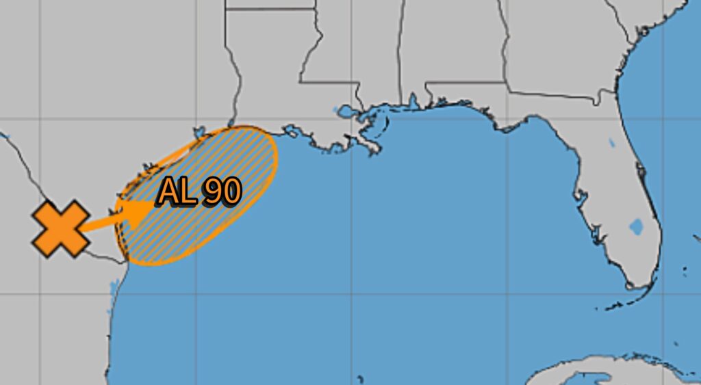
The good news for Marco Island is that AL90 is currently expected to remain far west of Florida, with the greatest impacts focused on Texas, Louisiana, and portions of Mississippi. The National Hurricane Center says the disturbance near the Texas/Mexico border has about a 60% chance of becoming a short-lived tropical storm as it moves into the northwestern Gulf. (National Hurricane Center)
📍 Direct Impact on Marco Island
At this time:
✅ No significant wind threat expected for Southwest Florida
✅ No storm surge threat for Marco Island
✅ No tropical storm watches or warnings anticipated for Florida
✅ System forecast to remain in the northwestern Gulf near Texas and Louisiana (National Hurricane Center)
🌦️ Indirect Effects Possible
Marco Island could still see a few minor impacts:
Increased tropical moisture over Florida later this week
Higher rain chances and scattered afternoon thunderstorms
Rougher Gulf waters at times
Elevated rip current risk on some beaches
Enhanced lightning activity during afternoon storms
These effects would be typical Florida summer weather rather than direct tropical-storm conditions.
🌡️ Marco Island Outlook
Tuesday–Friday
Highs: 89–92°F (32–33°C)
Lows: 75–78°F (24–26°C)
Daily rain chances: 40–60%
Gulf waters: generally 2–4 feet
Water temperature: around 86°F (30°C)
🔮 Bottom Line
For Marco Island residents and visitors, AL90 currently looks more like a weather story than a tropical threat. Unless the system unexpectedly turns eastward—which forecast models do not currently indicate—the main impacts here will likely be nothing more than a slight increase in tropical moisture and scattered thunderstorms. (National Hurricane Center)
Threat Level for Marco Island: 🟢 Very Low (1/10)
I’ll keep watching it closely, but as of Tuesday morning, AL90 appears to be a Texas-Louisiana flooding event, not a Florida storm. 🌴🌀