
Marco Island Weekly Weather Forecast: Warm Sunshine, Breezy Beaches and Showers Ahead
Saturday, October 24 – Friday, October 30, 2026
MARCO ISLAND, FLORIDA — Marco Island residents and visitors can expect another warm week in Southwest Florida, with afternoon temperatures climbing into the mid-80s, a mixture of sunshine and clouds, and several opportunities for passing showers.
The seven-day forecast begins Saturday, October 24, with pleasant weather and very little chance of rain. Conditions become breezier and more unsettled Sunday through Wednesday before improving toward the end of the week.
High temperatures will generally range from 84°F to 86°F (29°C to 30°C), while overnight lows remain comfortable in the upper 60s and lower 70s.
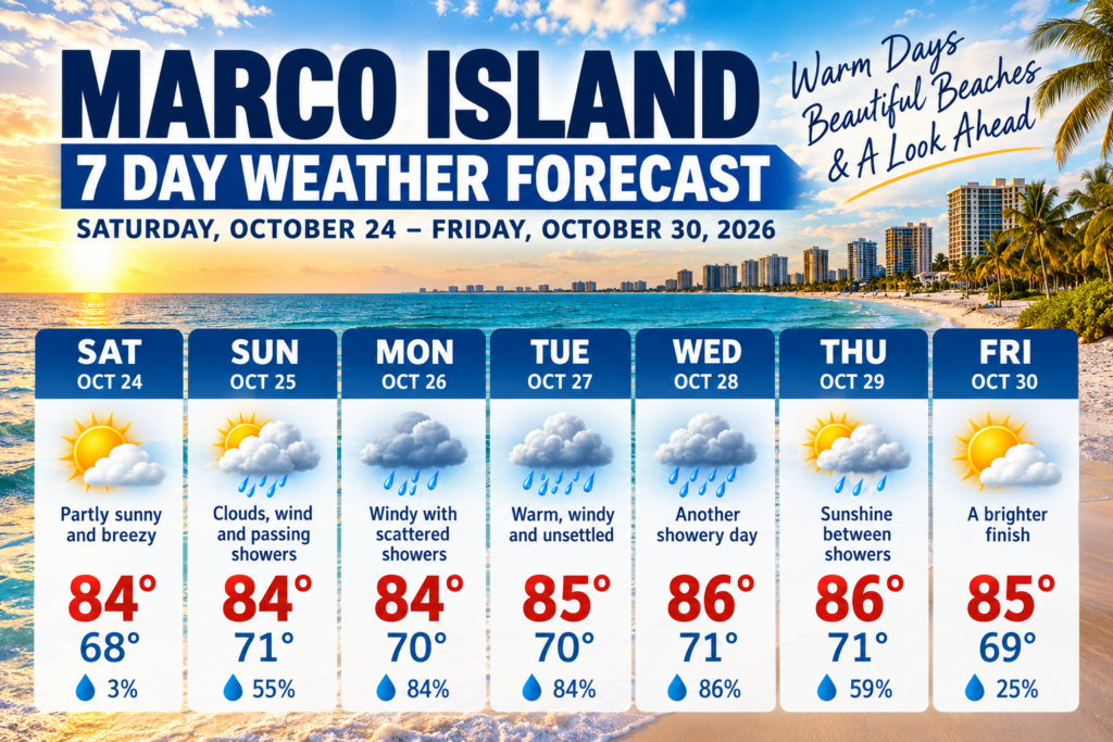
🌤️ Marco Island 7-Day Weather Forecast
SATURDAY, OCTOBER 24
84°F (29°C)
Partly sunny and breezy
Low 68°F (20°C) · Rain 3%
Sun 25
84°
71°
55%
Mon 26
84°
70°
84%
Tue 27
85°
70°
84%
Wed 28
86°
71°
86%
Thu 29
86°
71°
59%
Fri 30
85°
69°
25%
📅 Day-by-Day Weather Outlook
☀️ Saturday, October 24 — A Beautiful Start to the Weekend
Saturday looks like one of the best days of the week for outdoor activities. Expect intervals of sunshine and clouds, with breezier conditions developing during the afternoon. Rain chances are just 3%, making it an excellent day for beach walks, boating or lunch by the water.
🌦️ Sunday, October 25 — Clouds, Wind and Passing Showers
Sunday brings more cloud cover and increasing winds. A passing shower is possible, particularly around midday or late afternoon. Rain chances climb to 55%, although dry periods are still expected.
🌧️ Monday, October 26 — Windy With Scattered Showers
Monday will feature a mixture of sunshine and clouds, but the chance of showers increases significantly to 84%. The most likely period for rain is during the afternoon. Boaters should pay attention to changing wind and marine conditions.
🌦️ Tuesday, October 27 — Warm, Windy and Unsettled
Temperatures rise slightly to 85°F (29°C). Sunshine will alternate with cloudier periods, and showers may develop from late morning into the evening. The daytime precipitation chance remains elevated at 84%.
🌧️ Wednesday, October 28 — Another Showery Day
Wednesday could be the wettest day in terms of rain likelihood, with an 86% chance of precipitation. Despite the unsettled weather, temperatures may reach 86°F (30°C). Showers are expected to be intermittent rather than continuous.
🌤️ Thursday, October 29 — Sunshine Between Showers
Thursday offers a somewhat brighter outlook, with partly sunny skies and a chance of isolated afternoon showers. The daytime rain probability drops to 59%, although additional showers could occur during the evening.
☀️ Friday, October 30 — A Brighter Finish
Friday looks more favorable for outdoor plans, with partly sunny skies, a high near 85°F (30°C) and just a 25% daytime chance of rain. However, showers may return Friday evening.
🌊 Beach and Boating Outlook
The biggest weather concern this week may be the wind rather than the rain.
The National Weather Service forecasts northeast winds reaching 15–25 mph at times, with gusts potentially approaching 35 mph, particularly Sunday and Monday. These conditions could make boating and kayaking more challenging, especially in exposed waters.
Beachgoers visiting Tigertail Beach, South Marco Beach and nearby coastal areas should monitor local marine forecasts before entering the water.
☀️ What About the Rain?
There is some disagreement between forecast providers. While one seven-day forecast indicates a greater likelihood of showers from Sunday through Wednesday, the National Weather Service expects predominantly sunny conditions, with only isolated showers or thunderstorms on several days.
That means residents should not interpret the higher precipitation percentages as a prediction of all-day rain.
🏖️ Best Days for Outdoor Activities
Saturday looks particularly attractive for beach visits, walking and outdoor dining. Friday also offers a promising daytime forecast.
Sunday through Tuesday may still feature plenty of sunshine, but stronger northeast winds could affect boating, fishing and other marine activities.
🌴 The Bottom Line: Another Warm October Week on Marco Island
Marco Island is heading into the final full week of October with weather that still feels like summer in many other parts of the country.
Expect warm afternoons, comfortable evenings, breezy conditions and occasional opportunities for showers.
For residents, seasonal visitors and anyone planning a Southwest Florida vacation, the message is simple: keep the sunglasses handy, watch the wind if you’re heading onto the water, and don’t let the possibility of a passing shower spoil your plans