
Storm Charles Batters Southern Europe: Severe Flooding, Hundreds of Flights Cancelled and Italy on Red Alert
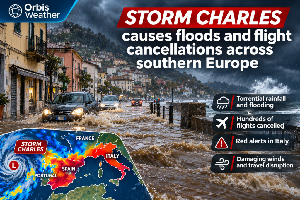
Storm Charles Batters Southern Europe: Severe Flooding, Hundreds of Flights Cancelled and Italy on Red Alert
Storm Charles has unleashed torrential rainfall, damaging winds and widespread travel disruption across southern Europe, flooding communities in Portugal, Spain and southern France while threatening further dangerous weather in Italy and the Balkans.
The powerful Atlantic storm has forced hundreds of flight cancellations, disrupted roads and prompted emergency precautions as authorities respond to the threat of flash flooding, landslides and damaging winds.
After striking Portugal’s Madeira archipelago, the storm swept across the Iberian Peninsula before tracking northeast towards France and Italy, bringing severe conditions to several countries in succession.
Portugal Hit by Extreme Rainfall and Powerful Winds
Portugal experienced some of the storm’s most severe conditions, particularly on the island of Madeira, where extraordinary rainfall totals and powerful wind gusts demonstrated the intensity of the weather system.
At Funchal Airport, winds reached approximately 136 km/h (85 mph), while rainfall accumulations reportedly reached 355 millimetres (14 inches) in just 12 hours.
That is an exceptional amount of precipitation over such a short period, capable of overwhelming drainage infrastructure, rapidly swelling streams and creating dangerous flash-flood conditions.
As Charles reached mainland Portugal on Wednesday, November 11, authorities took extensive precautions.
Schools and non-essential public services were closed nationwide, while transport networks faced major disruption.
Lisbon experienced flooded streets and severe travel interruptions. Portuguese authorities also established an emergency response operation to coordinate preparations and manage the developing situation.
Although the storm created considerable disruption, early reports indicated that Portugal had avoided the scale of destruction initially feared.
Hundreds of Flights Cancelled Across Portugal and Spain
Air travel was among the sectors most heavily affected by Storm Charles.
Lisbon Airport
183
Flights cancelled Wednesday
Madrid-Barajas Airport
155
Flights cancelled Wednesday
Strong crosswinds, heavy rainfall, poor visibility and thunderstorms can make airport operations hazardous, particularly during takeoff and landing.
Disruption may also continue after conditions improve because aircraft and crews must be repositioned and delayed services rescheduled.
Travellers flying through Portugal, Spain, southern France or northern Italy should check directly with their airlines before travelling to airports.
Spain Faces Flooding and Severe Weather Warnings
Across Spain, Storm Charles brought intense rainfall and strong winds, with southern and western regions particularly exposed.
Weather authorities issued high-level warnings as the storm crossed the Iberian Peninsula.
Parts of Cáceres and Ávila were placed under red rainfall warnings during the event, highlighting the potential for dangerous accumulations and flooding.
The greatest concern in areas experiencing repeated heavy rainfall is the speed at which normally manageable waterways can become hazardous.
Urban streets, low-lying roads, underpasses and locations close to rivers are especially vulnerable when intense rain overwhelms drainage systems.
Mountainous terrain introduces another danger: rainwater runs rapidly downhill, potentially carrying debris and destabilising slopes.
Southern France: Flooding and Rockfalls Along the French Riviera
After crossing Spain, Charles moved northeast into southern France, bringing another round of heavy rainfall.
The French Riviera experienced significant disruption, including flooding around Cannes.
Heavy precipitation also triggered rockfalls and road closures, illustrating how prolonged or intense rainfall can create hazards beyond flooded streets and rivers.
In steep coastal areas, saturated hillsides may become unstable, increasing the danger of falling rocks, mud and debris.
Motorists should avoid flooded roads and follow local restrictions, particularly where emergency crews are inspecting damaged or unstable routes.
Italy Issues Highest-Level Rainfall Warning
Attention has now shifted eastwards as the storm system threatens northern and central Italy.
Italian weather authorities have issued red-level rainfall warnings, the highest category, across an area extending from Tuscany towards Venice.
Forecast guidance indicates that additional rainfall could become substantial across Italy and parts of the Balkans over the coming days.
FORECAST RAINFALL — ITALY AND BALKANS
100 mm
About 3.9 inches possible across widespread affected areas
200 mm
Nearly 7.9 inches possible in some mountainous locations
These rainfall amounts would be particularly concerning in areas where soils are already saturated or rivers are running high.
Northern Italy’s geography can intensify flooding risks. Moist air rising over mountain ranges cools and condenses, potentially producing heavier rainfall on windward slopes.
Water then drains into river valleys and low-lying communities, sometimes creating flooding far downstream from the areas receiving the heaviest precipitation.
The most important developments to monitor are the precise location of the heaviest rainfall, river responses and whether official warnings are extended or upgraded.
Why Storm Charles Has Been So Disruptive
Storm Charles illustrates how a large Atlantic low-pressure system can create several different types of hazards as it moves across Europe.
Strong pressure differences around the system generate powerful winds, while moisture transported from the Atlantic supplies heavy rainfall.
As weather fronts interact with the complex terrain of Portugal, Spain, France and Italy, rainfall can become concentrated in particular locations.
Three processes help explain the disruption.
Atlantic moisture transport: Strong winds can carry substantial amounts of water vapour into western Europe, providing the moisture needed for intense precipitation.
Orographic enhancement: Mountain ranges force moist air upwards, cooling it and encouraging additional rainfall.
Repeated exposure: As the storm and its associated fronts move across multiple countries, different communities can experience flooding, wind damage and transport disruption over several days.
This combination can turn a single storm system into a regional emergency affecting millions of people and several national transport networks.
What Happens Next? November 13–15 Outlook
As of Friday, November 13, the principal concern is the potential for further heavy rainfall across Italy and the Balkans.
Forecast models suggest that some locations could receive significant additional precipitation, especially in mountainous areas.
The main hazards to watch through the weekend include:
-
Flash flooding in urban and low-lying locations.
-
Rising rivers and flooding in vulnerable catchments.
-
Landslides and rockfalls on saturated slopes.
-
Disruption to roads, railways and aviation.
-
Dangerous driving conditions during intense rainfall.
These are forecast risks rather than confirmation that every affected area will experience severe conditions.
Residents and travellers should follow their national meteorological services and local civil protection authorities for location-specific warnings.
Safety Advice for Residents and Travellers
Anyone in an area affected by heavy rainfall should avoid unnecessary journeys during the most severe conditions.
Never attempt to drive through floodwater. Water depth, road damage and current strength can be difficult to judge, particularly at night.
People living near rivers or steep hillsides should monitor official alerts and be prepared to follow evacuation instructions if issued.
Travellers should check flight status directly with airlines and allow additional time for journeys where roads and public transport may be disrupted.
For emergency assistance, the European emergency number is 112.
Weather Analysis: A Widespread European Weather Emergency
Storm Charles demonstrates how quickly an Atlantic storm can disrupt daily life across an entire region.
From the extreme rainfall recorded in Madeira to airport cancellations in Lisbon and Madrid, flooding on the French Riviera and heightened warnings in Italy, the storm’s impacts have extended far beyond its initial landfall.
The next critical period will depend on how much additional rain falls across northern Italy and the Balkans, and whether river systems can accommodate the incoming water.
Even after the heaviest rainfall ends, flooding and landslide risks can persist as water continues to move through rivers and saturated ground.
For southern Europe, the immediate priority remains public safety, transport recovery and monitoring the next phase of heavy rainfall.
Sources and Weather Verification
This report is based on information published and available on November 13, 2026, including: