
North America Weather & Natural Hazards Today
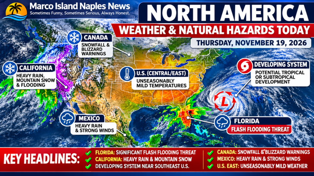




North America Weather & Natural Hazards Today – November 19, 2026
Thursday, November 19, 2026 | Marco Island Naples News
Florida Faces Significant Flash Flooding Threat as California Battles Heavy Snow, Pacific Storms Sweep West and a Potential Tropical System Develops Near the Southeast Coast
North America is experiencing a sharp contrast in weather conditions this Thursday, November 19, with dangerous flooding threatening Florida, a powerful Pacific storm bringing heavy mountain snowfall to California, and unusually mild November temperatures spreading across portions of the central and eastern United States.
The most concerning development is unfolding across Florida, where repeated heavy rainfall is creating a significant flash flooding threat. Meanwhile, meteorologists are monitoring a developing weather system near the Bahamas that could acquire tropical or subtropical characteristics during the coming days.
Across the western United States, heavy rain, mountain snow and difficult travel conditions are creating additional hazards ahead of the Thanksgiving travel period.
Here is today’s North America Weather & Natural Hazards Report, covering the United States, Canada, Mexico and the surrounding regions.
1. Florida – Significant Flash Flooding Threat
Florida is among the most vulnerable areas in North America today as a prolonged period of heavy rainfall affects the eastern and central portions of the peninsula.
The NOAA Weather Prediction Center has issued a Moderate Risk of excessive rainfall for portions of eastern and central Florida for Thursday, with another Moderate Risk forecast for Friday.
Particularly vulnerable areas include portions of South Florida, where substantial rainfall has already fallen.
Some locations in Broward County have experienced extraordinary rainfall totals, with reports of 12–17 inches (305–432 mm) in the Hollywood–Pembroke Pines area.
Additional rainfall could produce dangerous flash flooding, especially in urban communities, low-lying neighborhoods and areas with poor drainage.
The threat is expected to continue into Friday as atmospheric disturbances move across the peninsula and a low-pressure system develops near the Bahamas.
Residents should avoid flooded roads, monitor local emergency alerts and remain aware that flood conditions can deteriorate rapidly.
2. Potential Tropical or Subtropical Development Near Florida and the Bahamas
The National Hurricane Center is monitoring an area of disturbed weather near the northwestern Bahamas and Florida associated with a frontal boundary.
A non-tropical low-pressure system is expected to form near the northwestern Bahamas on Friday. As it moves northward or northeastward near the southeastern United States coastline, environmental conditions could allow the system to become a tropical or subtropical storm.
Formation chance – 48 hours
20%
Low
Formation chance – 7 days
60%
Medium
Regardless of whether the system receives a name, strong winds, dangerous surf and coastal flooding are possible along portions of the southeastern and mid-Atlantic United States coastline through the weekend and into early next week.
There are currently no active tropical cyclones in the Atlantic basin. However, this developing system demonstrates why coastal communities should continue monitoring tropical weather even during the final weeks of hurricane season.
The Atlantic hurricane season officially continues until November 30.
3. California – Heavy Rain, Mountain Snow and Dangerous Travel
A powerful Pacific weather system continues affecting California, bringing heavy precipitation, mountain snowfall and localized flooding.
The Sierra Nevada is experiencing particularly hazardous winter weather, with heavy snowfall expected to continue into early Friday.
At lower elevations, rainfall is creating flooding concerns, especially in central and southern California.
The Los Angeles Basin and nearby mountain communities face localized flash flooding risks. Forecasters expect approximately 1–2 inches (25–51 mm) of rainfall in some mountain areas, potentially falling within a relatively short period.
Locations affected by previous wildfires are especially vulnerable because burned terrain can generate rapid runoff, debris flows and mudslides.
Travelers crossing mountain passes should prepare for rapidly changing road conditions, poor visibility and possible travel restrictions.
Additional Pacific storms are forecast to approach the West Coast during the days leading up to Thanksgiving, potentially prolonging the unsettled conditions.
4. Western United States – More Storms on the Horizon
Beyond California, the broader western United States is entering an active late-November weather pattern.
Forecast hazards include mountain snowfall across portions of the interior West and central Rockies, additional heavy rainfall along the Pacific Northwest coastline and potentially strong winds near coastal Washington early next week.
Southern Alaska and southeastern Alaska also face periods of heavy precipitation and strong winds.
With Thanksgiving approaching, changing weather conditions could disrupt road travel through mountain corridors and affect some air transportation.
The continuing series of Pacific disturbances means conditions may improve temporarily between systems before deteriorating again.
5. Canada – Snowfall, Blizzard Warnings and Air Quality Concerns
Canada is experiencing several distinct weather hazards today, with winter conditions affecting parts of the Prairie provinces and the Arctic.
Environment and Climate Change Canada lists snowfall warnings across portions of southwestern Saskatchewan, including communities around Maple Creek and the Cypress Hills.
In Nunavut, blizzard warnings affect Clyde River and Qikiqtarjuaq, where blowing snow and reduced visibility create dangerous conditions.
The Yukon also has a blowing snow advisory affecting the Dempster Highway region.
Meanwhile, British Columbia faces a different environmental concern, with air quality warnings affecting the Bulkley Valley, Prince George and Stuart–Nechako areas.
Residents in affected communities should monitor official warnings, particularly when traveling across exposed highways or remote northern routes.
6. Mexico – Cold Fronts Bring Heavy Rain and Strong Winds
Mexico is experiencing a combination of heavy rainfall, strong winds and contrasting temperatures as frontal systems influence the country.
According to Mexico’s National Meteorological Service, Cold Front Number 6 is positioned over the southwestern Gulf of Mexico.
Heavy rainfall of 25–50 mm (1–2 inches) is forecast for portions of Veracruz, Oaxaca, Chiapas and Tabasco.
The strongest winds are expected around the Isthmus and Gulf of Tehuantepec, where gusts could reach 60–80 km/h (37–50 mph).
A separate frontal system is approaching northwestern Mexico, bringing additional wind and showers to Baja California.
Temperature contrasts remain pronounced. Some coastal and western regions could reach 35–40°C (95–104°F), while mountainous areas of northern Mexico may fall to -5–0°C (23–32°F).
Flooding, landslides, dangerous coastal conditions and reduced road visibility are among the principal concerns.
7. Central and Eastern United States – November Warmth Expands
While Florida faces flooding and the western states contend with stormy conditions, much of the central and eastern United States is experiencing a comparatively mild weather pattern.
Temperatures are forecast to rise above typical mid-November levels across several regions.
Parts of the eastern United States could experience afternoon highs in the 60s°F (approximately 16–21°C), with generally quieter weather away from Florida.
However, this warmth is not expected to eliminate the possibility of rapidly changing conditions later in the month as additional weather systems move across the country.
The contrast between mild eastern temperatures and heavy western mountain snowfall illustrates the considerable regional differences in North America’s late-autumn weather.
8. Thanksgiving Travel Outlook – Storm Risks Continue
With Thanksgiving approaching on Thursday, November 26, travelers should monitor several developing weather hazards.
Pacific storm systems could bring additional rain, mountain snow and strong winds to the western United States during the holiday travel period.
Meanwhile, the developing low-pressure system near the southeastern United States could generate coastal flooding, dangerous surf and strong winds along parts of the Atlantic coastline during the weekend and early next week.
These developments could affect road conditions, coastal activities and some transportation schedules.
The precise timing and severity of impacts will depend on how the systems evolve.
North America Natural Hazards Summary – November 19, 2026
|
Region |
Primary hazard |
Concern |
|---|---|---|
|
Eastern and Central Florida |
Heavy rain, flash flooding |
High |
|
Southeast U.S. Atlantic Coast |
Developing low, coastal flooding |
Elevated |
|
California |
Heavy snow, rain, flooding |
High |
|
Pacific Northwest |
Incoming storms, wind |
Elevated |
|
Canadian Prairies |
Snowfall, winter travel |
Elevated |
|
Canadian Arctic |
Blizzard conditions |
High |
|
Northern British Columbia |
Air quality |
Elevated |
|
Southeastern Mexico |
Heavy rain, strong winds |
Elevated |
|
Central and Eastern U.S. |
Unseasonably mild weather |
Generally lower |
Qualitative hazard assessment based on available forecasts and warnings, not an official standardized risk scale. Conditions vary locally.
What to Watch Over the Next 72 Hours
The most important weather developments across North America will be the continuing Florida flood threat, possible tropical or subtropical development near the Bahamas, heavy snowfall in California and the arrival of additional Pacific storm systems.
Florida’s flooding remains an immediate concern, while the developing Atlantic coastal system could become increasingly important during the weekend.
Residents and travelers should pay particular attention to changing forecasts and warnings as these systems evolve.
Official Weather Sources
For current warnings, radar and forecast updates, consult:
Final Outlook
North America’s weather on November 19, 2026, is dominated by two major concerns: dangerous rainfall across Florida and powerful Pacific storms affecting the western United States.
The possibility of tropical or subtropical development near the southeastern U.S. coastline adds another dimension to an already active weather pattern.
For Southwest Florida residents, the most important distinction is that the greatest immediate flood threat is concentrated across eastern and central Florida, rather than uniformly across the entire peninsula. Nevertheless, anyone traveling across the state should monitor conditions carefully.
As the Thanksgiving travel period approaches, the combination of flooding, mountain snowfall and developing coastal storms deserves close attention.
Marco Island Naples News – North America Weather & Natural Hazards Today.
Published Thursday, November 19, 2026. Based on meteorological information and official forecasts available during the morning of November 19. Forecasts and warnings are subject to change